In 1996 Arab Surveyors started a new field of survey as a marine survey and acquired necessary instruments including duel frequency Echo sounders, current meter, wave recording and tide gauge, software’s, staff.
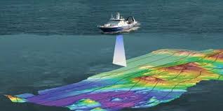
Marine Survey
In 1996 Arab Surveyors started a new field of survey as a marine survey and acquired necessary instruments including duel frequency Echo sounders, current meter, wave recording and tide gauge, software’s, staff.
Survey by Drones
Arab Surveyors in 2017 introduced and got licenses to use Drones (UAV) in Jordan and in Saudi Arabia and we did successfully 1000 square Km project at NEOM in Saudi Arabia and a Railway project in a mountainous area for Dar Al Handasah in Aqaba Region
Latest Technology
These surveys may be conducted by the orthodox survey method or by ground control of aerial photos. The Arab Surveyors is fully equipped with the most advanced survey instruments, staffed and prepared to undertake surveying services anywhere.
In 1986 the Arab Surveyors purchased and installed in Amman office computer facilities including the well know survey and highway software packages (ECLIPSE / PANTERRA).
The Arab Surveyors are licensed to use above software and has a maintenance agreement with GMS. of U.K. for updating these packages.
A licensed copy of above software is also installed in our Beirut & Riyadh Offices.
To minimize field observation errors Arab Surveyors updated the field survey instruments with the newly Duel Frequency Leica GPS system, electronic total stations linked to field computers as data loggers.
Latest Software
Leica Geo Office with almost all options for solving GPS Observations Least Square Adjustment etc… version 8.1.
SonarLite Software for downloading, calculating and merging Echo Sounder observations with GPS observations.
HYPACK 2020 Software which provide all tools necessary to meet almost any bathymetric survey includes Navigation, logging of data, apply corrections to soundings and processing.
Wave for Windows Software from InterOcean Systems Inc.
AutoCAD latest Versions.
CIVIL 3D from Autodesk: is an interactive multipurpose, three-dimensional ground modeling system, It consist of suite of programs developed for surveying and civil engineering.
PIX4D Mapper Software which is a suite of software products that use photogrammetry and computer vision algorithms to transform both RGB and multispectral images into 3D maps and models. It is developed and supplied by the company Pix4D SA, which started in 2011 as a spinoff of the École Polytechnique Fédérale de Lausanne (EPFL) Computer Vision Lab in Switzerland .Its software solution lines operate on desktop, cloud, and mobile platforms. Pix4D has been used to map both the Matterhorn mountain in Switzerland. Pix4Mapper is an exceptional automatic triangulation package that delivers fully automated aerial triangulation from interior orientation to the determination of tie points to the final block adjustment analysis with delivery of orientation parameters. Pix4Mapper generate ortho rectified photos in TIFF format and also generate a very dense point cloud (almost every pixel) by image auto correlation. This point cloud will be the source of DTM generation. The point cloud generated is then taken to civil 3D software for more editing, processing and production of 2d and 3D drawings.